[MAP OF POLAND AND THE BALTIC STATES] ALBRECHT CARL SEUTTER Ducatus Pomeraniae Citerioris et Ulterioris. Principatibus, Comitatibus urbibus suis definitae Nova et Ampla Descriptio geographica.
Lotto 702
1 1001 500
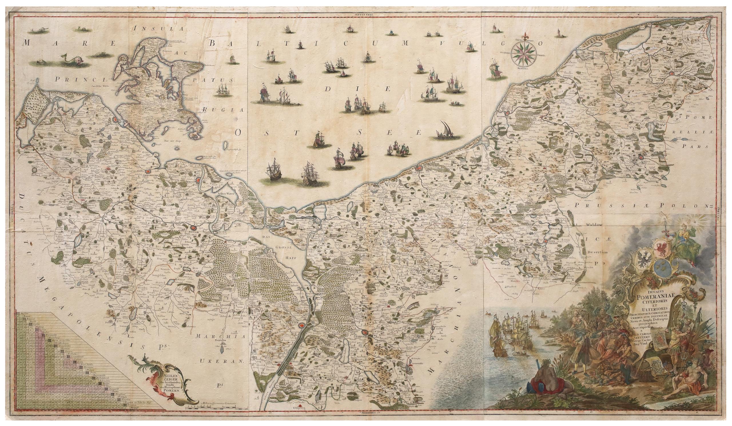
Augsburg, c. 1760.
Six sheets joined to one large map, 98 x 167.5 cm.
Map and title cartouche coloured. Paper slightly browning.
First edition of Seutter’s 6-sheet map of Pomerania, first published in about 1760. The map was later re-issued by Conrad Tobias Lotter, with the title re-engraved. Seutter’s map is a simplified version of Lubben’s map, issued in approximately the same scale, but with numerous revisions and improvements. Showing the region on the south coast of the Baltic shared between Germany and Poland, from the Recknitz River near Stralsund in the west, via the Oder River delta near Szczecin, to the mouth of the Vistula River near Gdansk in the east. Created by Professor Lubben of Rostock University on the orders of Philipp II, Duke of Pomerania, who wanted a large-scale map that would be a comprehensive geography and history of the duchy. Although Lubben had mapped the island of Rugen on the Pomeranian coast in 1609, he had very little geographic information to guide him: the only map to precede this one of Pomerania was a small map by Peter Artopaus (later used by Münster and Ortelius). Lubben spent two years travelling throughout the country taking thousands of measurements, it was then another 6 years before the copperplates were completed, by Geelkerken in Amsterdam. However, although a very small number of the sheets printed in 1618 are known to have been presented to the Pomeranian court, the shortage of paper, and the 30 Years’ War intervened, and no known copies of this printing have survived. It was not until 1757, after Geelkerken’s original copperplates were discovered in the in Stralsund (a town featured in a vignette on the map), that the map was reissued. Lubben’s map was the model for virtually all atlas maps of Pomerania of the seventeenth century, including those of Blaeu and Janssonius, and Hondius dedicated his famous wall map of Asia to Lubben: see Shilder, «Monumenta Cartographica Neerlandica» VI, pp.150-151. It remained the only map of consequence of the region from its inception in 1618 until the Prussian topographical survey of the eighteenth century.